
Operation Dronagiri
Intelligent hyperlocal weather & microclimate forecast to empower farmers and businesses .
About the Association
This startup is associated with the Technology Innovation Hub (TIH) on Positioning and Precision Technologies (PPT) at IIT Tirupati Navavishkar I-Hub Foundation (IITTNiF) through Operation Dronagiri, a flagship initiative of the Department of Science & Technology (DST) Geospatial Data Promotion and Development Committee (GDPDC)and the Geospatial Innovation Cell (GIC) under the National Geospatial Policy (NGP).
Operation Dronagiri demonstrates the power of geospatial technology in transforming Agriculture, Transportation & Infrastructure, and Livelihood & Skilling, aligning with the national vision of Viksit Bharat 2047.
The initiative is powered by the Geo-Intel Lab, the Geospatial Intelligence and Applications Laboratory of IITTNiF, which develops applications and platforms for public good and digital governance. The lab integrates GIS, Remote Sensing, GNSS, and Data Analytics to deliver scalable decision-support systems and hosts India’s first Federated Geospatial Data Interface (GDI) node, enabling seamless data access and collaboration across the national geospatial ecosystem.
All products and platforms developed under this collaboration will be featured on the National Geo-Intel Portal.
Problem Statement
Addressing climate unpredictability and extreme weather events that cause significant agricultural and operational losses.
GIA Partner
SINE, IIT Bombay
Pilot District
Washim, Maharashtra
Solution Overview
WeatherCast Solutions provides a state-of-the-art deep-tech weather forecasting platform powered by our patented proprietary Model. We deliver highly accurate hyperlocal weather predictions using a powerful blend of meteorology, physics, IoT data, big data analytics, and AI/ML. Our solution enables farmers and businesses to make informed decisions, minimize weather-related losses, and optimize their operations through real-time monitoring and precise forecasting at hyperlocal scale.
Geospatial Datasets Utilized (GDI)
- Real-time IoT sensor network data
- Weather model outputs and forecasts
- Historical climate and meteorological data
Team Members

Tushar Senghani
Sr. Data Scientist

Biswajit Sahoo
Meteorologist

Arpit Mohapatra
Jr. Meteorologist
Gallery
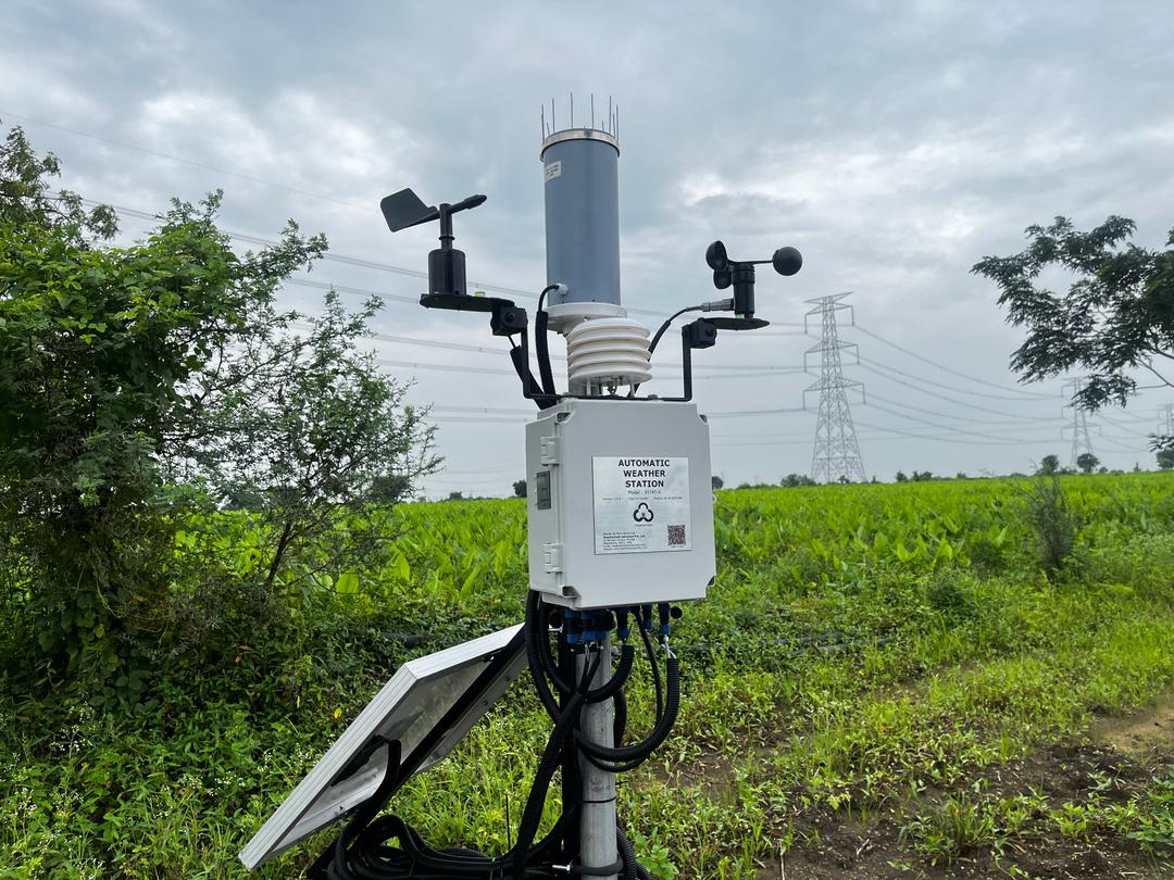
Current Pilot Status
Active deployment in Washim district with 3 weather monitoring weather stations installed and serving real-time weather forecasting.
Partnerships & Collaborations
- ▸ Government: State Agriculture Department
- ▸ Academia: IIT Tirupati, IIT Bombay
- ▸ Industry: farmer cooperatives
How Our Solution Supports These Goals
Extreme weather events like lightning, heavy rainfall, heatwaves, and unseasonal temperature shifts are increasingly disrupting farm productivity and farmer safety. Most government weather bulletins cover only district or block levels, missing critical hyperlocal variations that directly affect panchayat-level decisions. WeatherCast bridges this gap through precise, hyperlocal agro-advisories powered by our AI/ML weather model. Farmers receive 7-day forecasts and actionable insights to plan sowing, irrigation, pest control, and harvesting with confidence.